The Beaver River, Black Bay, Don Lake, Gulch, Larado, and Smitty projects are located in the Beaverlodge District near Uranium City in the Lake Athabasca region of Saskatchewan. Occurrences of uranium
mineralization are abundant in the region and have been explored and documented since the 1940s.
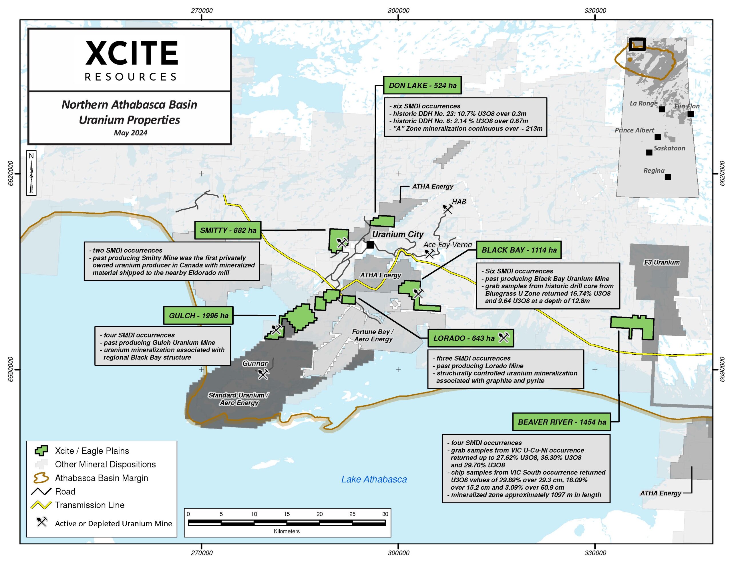

- Four Saskatchewan Mineral Deposit Index (“SMDI”) occurrences.
- Grab samples from VIC U-Cu-Ni occurrence (SMDI 1553) returned from trace values up to 27.62%
U3O8, 36.30% U3O8 and 29.70% U3O8 (AF 74O05-0051); mineralized zone approximately 1097m in
length (AF 74O05-0066). - Rock chip samples at SMDI 1994, 800m southeast of VIC occurrence, returned U3O8 values of
29.89% over 29.2cm, 18.09% over 15.2 cm and 3.09% over 60.9 cm (AF 74O05-0077).
- Six SMDI occurrences.
- Black Bay Uranium Mine (SMDI 1296) discovered in 1953; mineralization developed in three main
shoots discovered along a strike length of approximately 152.4m (500’) and a down-dip distance
of 731.5m (2400’); 1355 tons produced at 0.17% U3O8. - Grab samples from the drill core at Bluegrass U Zone (SMDI 1295), located 600m northwest of
Black Bay Mine, returned 16.74% U3O8 and 9.64% U3O8 at a depth of 12.8m.
- Six Saskatchewan Mineral Deposit Index (“SMDI”) occurrences.
- Discovered in 1950 by Eldorado Mining and Refining.
- Drilling at Don Lake A, B, and C Zones (SMDI 1393) returned values of 10.7% U3O8 over 0.3m in
- DDH No. 23 and 2.14% U3O8 over 0.67m in DDH No.6 from a sheared and brecciated granite (AF74N10-0422).
- Zone mineralization continuous over approximately 213m.
- 20 km SW of Uranium City.
- Four SMDI occurrences.
- Uranium mineralization associated with the regional Black Bay structure.
- 1953-57 underground development at Gulch Uranium Mine (SMDI 1221) outlined 11 mineralized shoots.
- 1954 trenching at Lucy (SMDI 1223) returned values from below detection to up to 0.37% U 3O8 over 3m.
- Duvex Oils and Mines Radioactive Zones (SMDI 1224) grab samples returned values from trace up to 2.23% U3O8.
- Last documented work in 2015 concluded that anomalous U mineralization was structurally controlled similar to the past-producing Gulch uranium mine and further work, including deeper drilling, was recommended for the property.
- 10km S of Uranium City along Saskatchewan Provincial Highway 962.
- 3 SMDI occurrences.
- Larado Uranium Mine (SMDI 1228) saw extensive underground development and production from 1953-1960; structurally controlled uranium mineralization associated with graphite and pyrite.
- Pitchie Uranium Zone (SMDI 1229) is located 850m southwest of the Larado Mine; main zone uranium mineralization exposed on the surface for 91m; historical work includes approximately 50 diamond drill holes, the majority of which were less than 100m in length.
- 2 SMDI occurrences.
- In 1954 became the first privately owned uranium producer in Canada with mineralized material shipped to the nearby Eldorado mill.